

Lifelines refer to the critical infrastructure communities rely on every day, such as roads, communications, power and water. The continual and growing exposure and vulnerability of lifelines to natural-hazard shocks means that lifeline failure during natural-hazard events may simply have to be expected.
The cascading nature of lifeline failure represents an emergent risk, in that natural hazards can now have complex and far-reaching impacts due to our reliance on interdependent and interconnected systems. It is therefore necessary to understand how lifelines and their functionality may be impacted when subjected to disruption from disasters, and furthermore, the social and economic costs of lifeline failure for at-risk populations.
This research explored the use of graph theory to gain a better understanding of the impacts of lifeline failure during natural-hazard events and assessed the usefulness of graph-theory techniques in aiding disaster mitigation, emergency response and community recovery. Graph theory is the study of networks through graphical representations. Graphs are mathematical structures made up of nodes and edges, which are used to represent network components and the connections between them. Various algorithms can be used to investigate network structure, evolution and robustness.

A future eruption of Mount Fuji in Japan was used as a scenario due to the volcano’s violent potential and close proximity to urban environments and lifeline infrastructure, and because of the availability of information and the willingness of prefecture governments, research centres and lifeline companies to discuss and identify where graph-theory techniques could assist their emergency plans. Field visits uncovered that the potential disruption of road transportation from volcanic ashfall was currently under-investigated. To address this gap, this study combined ash-dispersal modelling and Geographic Information System (GIS) tools with graph-theory techniques to assess the exposure of major roads to volcanic ash from a future eruption at Mount Fuji and to understand the impact of road closures on current evacuation plans for Yamanashi Prefecture.
Mount Fuji is the largest volcanic edifice in Japan (3,776m in elevation) and a national symbol. Its last eruption occurred in 1707, over 300 years ago, and it was one of the most violent eruptions the volcano has produced. The 1707 (Hoei) eruption produced widespread ashfall covering most of the south Kanto plain to the east of the volcano, impacting large proportions of Kanagawa and Chiba Prefectures, highly populated areas of Tokyo prefecture and parts of Shizuoka, Saitama and Yamanashi Prefectures (Figure 1). A future 1707-type eruption was used as the case study’s eruption scenario.
Although volcanic ashfall is not seen as an immediate threat to life, it can travel far from source and impact the operation of critical infrastructure such as electricity and transportation. The disruption of which has the potential to hinder disaster response and recovery operations, such as evacuation. The impact of volcanic ash on road transportation has been documented during past eruptions such as Mount St Helens (1980), Pinatubo (1991) and Shinmoedake (2011). Falling or remobilized ash has been found to significantly reduce driver visibility, and ashfall thicknesses of less than 1mm can obscure road markings (Figure 2). Fine ash can also make road surfaces slippery, especially when wet, can abrade vehicle components and clog air and oil filters (Wilson et al. 2012, Wilson et al. 2014, Blake et al. 2016, Blake et al. 2017, Wilson et al. 2017). For this case study a range of ashfall thickness thresholds (0.2–300mm) were used to determine the impact to road usability and therefore the potential disruption to Yamanashi Prefecture’s road network.

This scenario looked at two timestamps during the eruption: the first 1.5 hours of the eruption and the end of the eruption. This was done to look at the likely conditions Yamanashi residents could encounter during evacuation and after the event. Residents of the six closest cities to the volcano are set to evacuate at the onset of an eruption due to the life-threatening hazards (pyroclastic flows and lava flows) that can impact these areas. They are to travel to allocated host centres to the north, east and west of Yamanashi Prefecture via car (Figure 3). This study focused on the road usage between these cities and the evacuation centres and assessed the impact of ash-induced road closures on both evacuation and resident return. The modelled ashfall accumulations for the two timestamps were overlaid onto the road network. The road segments exposed to threshold ashfall depths were omitted from the network and the impact of this on road access was assessed. One particular example of how road closures can impact evacuation is outlined below.
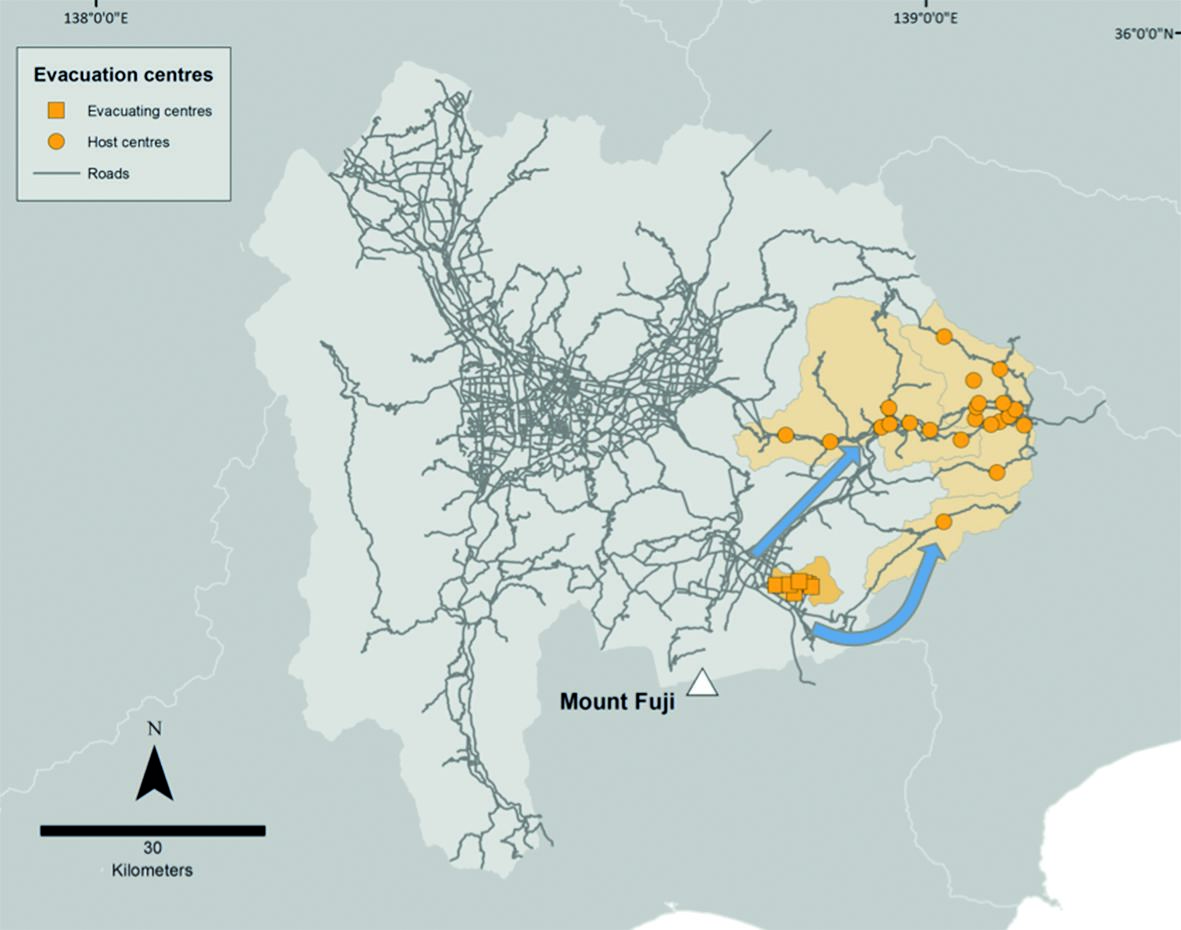
Figure 4 shows the starting locations of residents in the evacuating city of Oshino and the location of evacuation centres in the three host cities to the north east (Otsuki, Uenohara and Doshi). Figure 5 shows roads that would be impacted if closures occurred at 1mm or greater of ashfall accumulation. In this case road closures would not inhibit access to evacuation centres in host cities from Oshino. However, it would result in an average increase of 11.5km travel distance from some locations in Oshino to the evacuation centres in Doshi. Being able to predict this ahead of time would allow detours to be set up and potentially stop residents from getting stuck en route or having to turn back. In this scenario, if confident that the wind will not change direction, it would be recommended that residents of Oshino evacuate to the north before heading east to the host locations to avoid using easterly roads likely to be impacted by ashfall. Ashfall depths of 1mm can result in a loss of traction between vehicle wheels and the road surface, creating difficult and potentially dangerous driving conditions. In wet conditions ash can make the road even more slippery and can also be washed from the road surface into drainage systems, potentially leading to flooding of roads. Ashfall thicknesses of 1mm or greater can also cause flashovers to occur on power lines, which could impact electricity supply, and the traffic signals and streetlights that rely on it. Residents would need assistance in these conditions and roads may have to be cleared to allow safe passage.

Overall, the results found that, in the case of a future 1707-type eruption, with similar westerly wind conditions:
- Ashfall accumulation, after approximately 1.5 hours from the onset of an eruption, may inhibit the ability of Yamanashi residents to evacuate safely or unassisted.
- Ash-induced road closures cut off access to some evacuation centres and resulted in long detours for others, affecting current evacuation plans for Yamanashi Prefecture.
- Approximately 700km of roads in Yamanashi Prefecture would need to be cleared of ash and likely require repeated cleaning due to ash remobilization.
- Extensive clean-up operations, after the cessation of an eruption, could also hinder the movement and even the return of residents to their homes.
- Apart from motorways, roads that connected different cities within Yamanashi Prefecture were found to be the most important for evacuation and resident return. These roads could be prioritized for clean-up.
In summary, this research found that, with additional supporting information to appropriately weight network connections, there is great potential for graph-theory techniques to add value in the disaster-management space when combined with other tools – such as natural-hazard modelling and GIS – and integrated into holistic scenarios that incorporate inputs from all stakeholders.
The methods developed in this scenario can be applied in any context. Moreover, modelling lifeline disruption and the flow-on effects of service outage can be of use throughout the entire disaster-management process, from mitigation to response and recovery. Graph-theory techniques are useful for identifying critical components important to the functioning of networks. Knowing what area/population could be cut off from essential services such as power or water would enable communities to prepare for service outages. Emergency services would be able to determine transportation access for emergency response and evacuation and, in the aftermath of a disaster, determine which routes to open first for optimal recovery.
This research could be applied in an all hazard contexts where lifeline exposure and potential failure could be examined and compared between hazard types. There is also scope to take this research further by including lifeline interdependencies and modelling the potential propagations of service failure between lifeline networks. Another direction that could be taken would be to include economic data to quantify the cost of indirect disruption due to the loss of lifelines. In any case, any future research in this area will require the input and expertise of the lifeline sector. To become truly resilient to disruption from natural hazards, inter-agency collaboration is vital.
An in-depth description of all findings, including modelling results, from this research can be found in Singh (2019).
For more information, email emma.a.singh@gmail.com
Disclaimer
This work is part of Emma’s PhD research project, which was published in 2019. More information and detailed references can be found in Singh, E. A. (2019) Modelling the impact of lifeline infrastructure failure during natural hazard events. Doctoral dissertation, Macquarie University, Faculty of Science and Engineering, Department of Environmental Sciences. http://hdl.handle.net/1959.14/1268491.
About the Author

Emma Singh is a PhD student with Risk Frontiers and the Department of Environmental Sciences at Macquarie University in Sydney. Emma is investigating critical infrastructure disruption during natural hazard events, with a particular interest in the implications of network failure for emergency response during and community recovery after a disaster.
